


BRISTOL TWP A Voting District, Trumbull County, Ohio
About
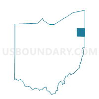
Outline

Summary
| Unique Area Identifier | 652749 |
| Name | BRISTOL TWP A Voting District |
| County | Trumbull County |
| State | Ohio |
| Area (square miles) | 8.28 |
| Land Area (square miles) | 8.28 |
| Water Area (square miles) | 0.00 |
| % of Land Area | 100.00 |
| % of Water Area | 0.00 |
| Latitude of the Internal Point | 41.39547160 |
| Longtitude of the Internal Point | -80.83338140 |
Maps


Graphs
Select a template below for downloading or customizing gragh for BRISTOL TWP A Voting District, Trumbull County, Ohio


Neighbors
Neighoring Voting District (by Name) Neighboring Voting District on the Map
- BLOOMFIELD TWP Voting District, Trumbull County, OH
- BRISTOL TWP B Voting District, Trumbull County, OH
- BRISTOL TWP C Voting District, Trumbull County, OH
- GREENE TWP Voting District, Trumbull County, OH
- MECCA TWP B Voting District, Trumbull County, OH
- MECCA TWP C Voting District, Trumbull County, OH
Top 10 Neighboring County Subdivision (by Population) Neighboring County Subdivision on the Map
- Bristol township, Trumbull County, OH (2,919)
- Mecca township, Trumbull County, OH (2,674)
- Bloomfield township, Trumbull County, OH (1,322)
- Greene township, Trumbull County, OH (1,015)
Top 10 Neighboring Unified School District (by Population) Neighboring Unified School District on the Map
- Maplewood Local School District, OH (5,696)
- Bristol Local School District, OH (5,648)
- Bloomfield-Mespo Local School District, OH (4,429)